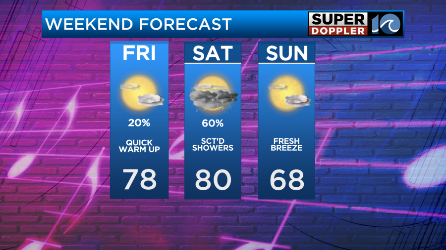
Things warm quite nicely for the initial portions of our weekend, before our next system moves into the region on Saturday. Not only does this give us our next shot at rainfall, but also a big temperature flip-flop!
Track 1
Lead Up by Goose
Leading up to this weekends frontal system, Friday warms nicely. High temperatures will sit on either side of 80° as the breeze develops out of the southeast. Expect sunshine early on, with increasing clouds by the end of the day. There could be a late day or late night shower, isolated at best, otherwise we’re looking dry.
Track 2
Scattered by Neil Young, Crazy Horse
Rain chances arrive on Saturday as the trailing cold front with the approaching system moves into the region. Right now, we can expect some prefrontal showers early in the morning, sometime around sunrise. There could be a break through the middle of the day, before the actual front moves in by the evening hours. Another round of scattered showers and even some thunderstorms would be possible then.
Track 3
Breathe (2 AM) by Anna Nalick
Late Saturday night the cold front will push south and in comes the dry, refreshing air on Sunday. That breathe of fresh air will feel very, very nice as sunshine takes over. High temperatures will be on either side of 70° with low humidity.
The sunshine setting up Sunday will last well into next week and things will warm up very quickly. 80s are back in the forecast next week — maybe even close to 90° in the extended forecast!
-Steve