
There are plenty of benefits to living by the water – in good weather. However, in the event of catastrophic conditions it is important to have plans in place to make sure you can get away from the area safely and as quickly as possible. It is important for residents to be prepared and ready to evacuate immediately, but only if instructed to do so.
Know Your Zone
It’s important to “Know Your Zone” with maps aimed at making evacuations easier. Experts spent three years using the most up-to-date engineering data to develop the new, interactive zone evacuation map. There are just four zones, and it’s simple to find yours online. All you have to do is type your address here.
Zone A is blue and is the most at-risk for flooding from a hurricane. The risk goes down from there: Zone B is green, C is orange and D is red. The zone map covers 23 localities and 1.25 million people living in Coastal Virginia.
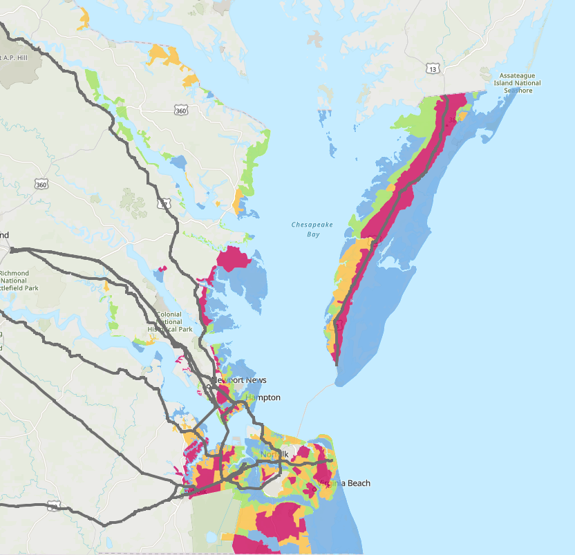
Click here for the “Know Your Zone” FAQ
Closure Plan For Bridges, Tunnels, Ferries
The Commonwealth of Virginia has developed safety guidelines for Hampton Roads’ bridges, tunnels and ferries. Wind speeds, storm surge, rain bands and other conditions at each bridge, tunnel and ferry are monitored constantly.
What factors does VDOT consider when deciding whether to shut down a water crossing during a hurricane?
- VDOT closes bridges, ramps or roads only when there is imminent danger to public safety, such as high water, structural damage or downed trees and debris blocking the roadway.
- Several variables play a role in the decision to close a bridge or tunnel. VDOT personnel will monitor forecasted and real-time measurements of high water and surge levels, winds, currents and the storm direction, among other factors, and make a decision based on the totality of those conditions.
- Bridges and tunnels at risk of flooding in Hampton Roads have an associated high-water mark that, if forecasted to be reached during a storm, will trigger closer monitoring by VDOT. Those levels are different depending on the facility (for example: 8 feet at the Midtown Tunnel and 7.5 feet at the HRBT).
- There are no set wind restrictions to vehicular traffic at any of the VDOT-operated bridges in Hampton Roads. (There are, however, wind restrictions at the Chesapeake Bay Bridge-Tunnel, which is operated by a separate authority.
- VDOT will communicate any plans to close a bridge or tunnel through local news outlets, 511Virginia and its own social media channels, including Twitter, Facebook and Nextdoor. For current travel information, the public can also call 511 or the Traffic Information Line at 757-361-3016, download Virginia’s free 511 mobile app or listen to Highway Advisory Radio (HAR) 1680 AM.
How does VDOT decide to reduce service at the Jamestown-Scotland Ferry or to move the boats off-site to safety?
- If VDOT and the U.S. Coast Guard determine the Jamestown-Scotland Ferry can safely operate one of more boats during inclement weather, service may be reduced, suspended or delayed for short periods depending on current conditions. For ferry traffic updates and operational status, call 1-800-VA-Ferry/1 (800) 823-3779.
- VDOT accounts for wind speed, wind direction and the track of the storm in considering whether to move the Jamestown-Scotland Ferry boats to safe harbor in Richmond. If VDOT moves the boats, service will be suspended until the ferry crew and the U.S. Coast Guard Captain of the Port determine they can return.
When would Virginia reverse traffic on I-64?
Only the governor can issue the order for an I-64 lane reversal.
Here’s where the I-64 lane reversal would be in effect:
Beginning just east of the Hampton Roads Bridge-Tunnel at mile marker 273, ending at the Interstate 295 interchange east of Richmond at mile marker 200.
What will a reversal mean for you?
No traffic will be allowed to travel east on Interstate 64 from just before the HRBT. All I-64 eastbound lanes and ramps between Norfolk and Richmond will be closed to eastbound traffic
to I-295 east of Richmond. The entrance to the reversed lanes on I-64 is in Norfolk, just east of the Hampton Roads Bridge-Tunnel, at mile marker 273.
There will be only two possible exits for traffic traveling on the reversed lanes between Norfolk and I-295. They are: Exit 234 in Williamsburg (Route 199) for gas, food, lodging and hospitals and Exit 205 in Bottoms Bridge for gas and food. There will be a comfort station on I-64 near Jefferson Avenue (mile marker 255) and the safety rest areas in New Kent County, which are accessible without exiting the interstate. Drivers who exit the reversed lanes at Exit 234 or Exit 205 cannot re-enter the reversed lanes. They can re-enter I-64 using the regular I-64 westbound ramps. Peninsula traffic will utilize I-64 westbound, entering and exiting regularly.
Here’s a good checklist before you leave:
- Make sure you have a full tank of gasoline.
- Get cash out early, ATM service may become interrupted.
- Make plans to secure your property.
- Shut off power, water, and gas. A professional has to turn your gas back on.
- Take extra supplies with you (food, water, etc). You may be stuck in traffic for a long period of time.
- Bring a cell phone and your charger/car adapter.
- Carry all valuables and important documents in a waterproof container.
- If you are traveling with children, make sure they have plenty of snacks, toys, books and movies to keep them entertained.
- If you are travelling with pets, be sure they have necessary supplies and accommodations.
- Follow roads that emergency workers recommend, even if there’s traffic. Other routes might be blocked.
- If you are outside of the WAVY-TV 10 viewing area, log on to WAVY.com for the latest updates or download the WAVY.com
Weather App for your smartphone. Click here for download instructions.