We are going to be dealing with a coastal storm this weekend, but the entire weekend won’t be a washout. Let’s talk about it…
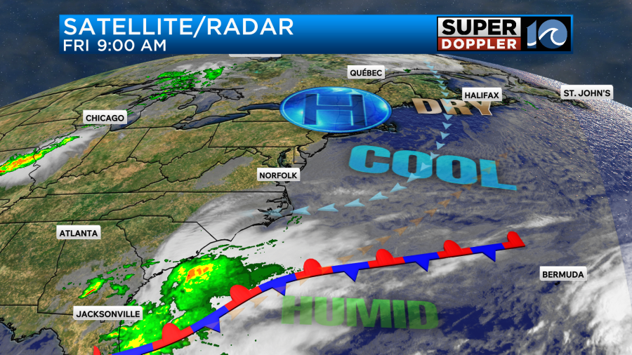
Today we will still have some decent weather. It will be pretty nice overall, but clouds will be increasing through the day. There is a cool front stalled out to our south. High pressure is to the north.
We’ll be partly cloudy today with more clouds by the mid-late afternoon. High temps will be in the upper 60s with a few 70s south.
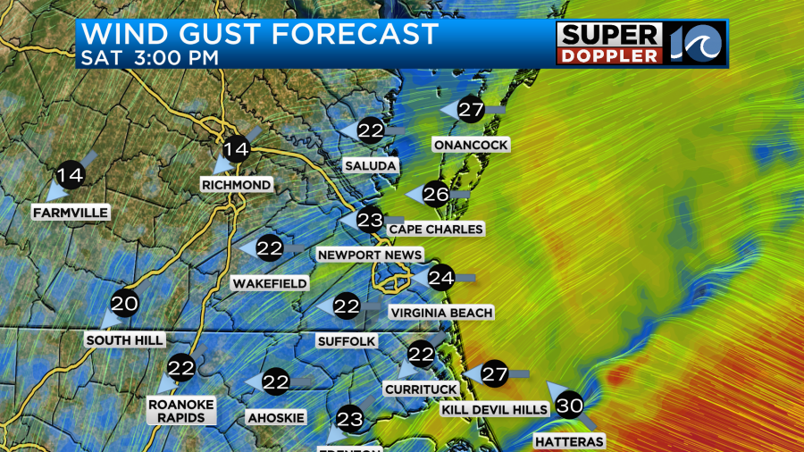
The wind will be out of the east. It will run at 10-15mph with gusts to 20mph. There will be a few gusts to 25mph near the shore.
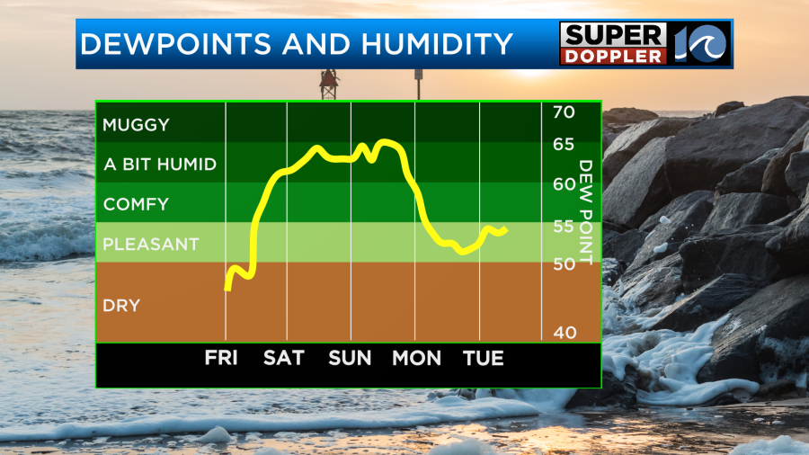
It is still very dry outside. So enjoy the fresh air while you can.
Down to the south along the front an area of low pressure will begin to form today. By tomorrow it will move north a bit, but it will still be to our south.

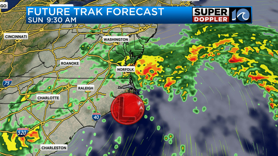
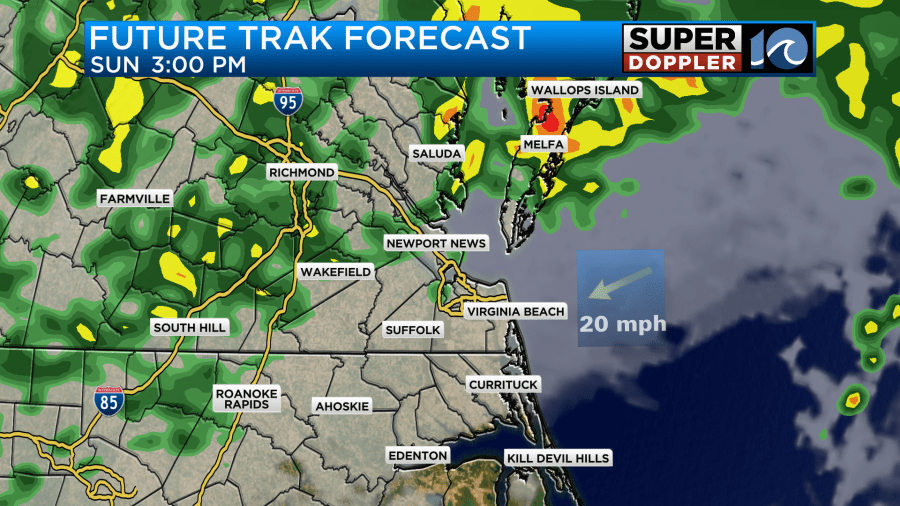
Moisture will push up into our region through the day. We’ll already have a lot of clouds. There may be some isolated showers during the morning. There could also be some drizzle developing as we go from the morning into the early afternoon. (That is a part of the forecast that is still tricky btw). (Yes.. I said btw). The trend is for an increasing chance for rain showers through the day. Here is Future Trak during the mid-late afternoon.
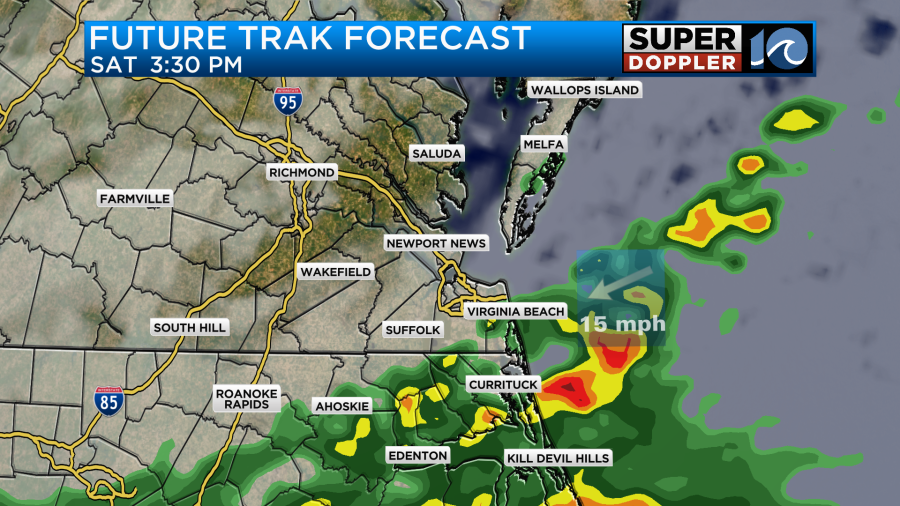
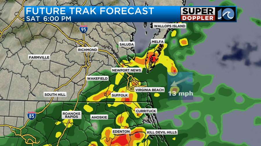
It even looks like it will become heavy by the early evening.
It will be breezy, but the wind still shouldn’t be too bad. Winds will gust out of the east at about 25mph. There will be some higher gusts across the Outer Banks.
High temps will be in the low 70s.
Wind and rain will increase from Saturday night into Sunday morning.
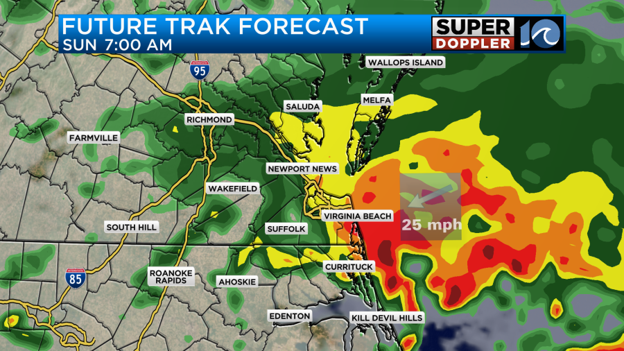
The low will be creeping up the coast through Sunday. I will say that the latest models do have the low stretched out a little more. This may help a little bit. The wind may not be quite as strong as yesterday’s forecast. The rain may also be less concentrated through the day. Having said that. The wind will be very strong through the day Sunday. Especially along the coast.
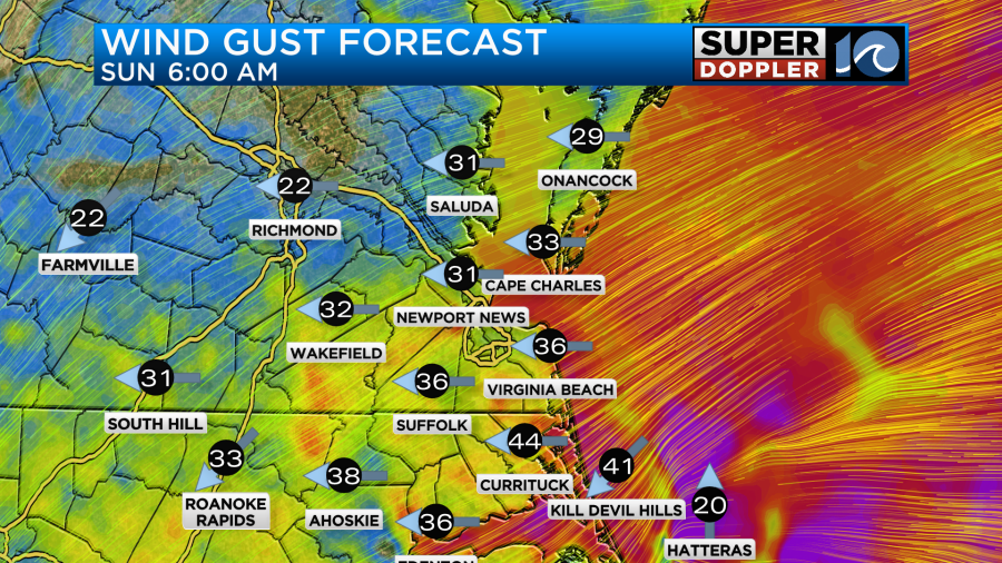
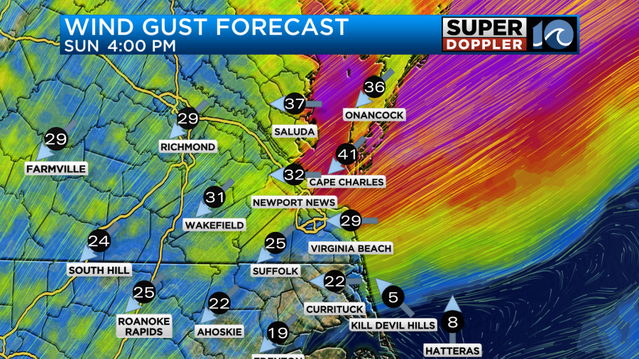
It looks like the stronger winds will rise north through the day. We’ll see if that lull develops to the south though. There could be some gusts between 40 and 50mph along the shore.
The rain will be on and off through the day, but the better chances do look like they will be in the morning for Hampton Roads.
The low will then push east on Monday. We’ll have some scattered rain showers and lots of clouds on the back side, but the winds should gradually lighten up. They will be out of the west/northwest.
As far as tidal flooding goes…The east/northeast winds over the next 48 hours will create some minor tidal flooding.
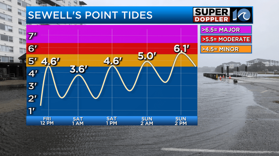
It should be low-end minor until Sunday morning. However, as the winds increase on Sunday the levels may get up into solid-moderate. That level will be about the same for Lynnhaven Inlet Sunday afternoon, but that level is considered “Major” at that location. There could be some other spots of major, but we’ll have to check back for the updates on that. Especially since the models have brought the winds down slightly already. There will likely be some more ocean overwash. Here is my forecast for that.

However, the details for this could also change a bit. Especially if that lull in the wind happens Sunday afternoon in that area. We’ll see.
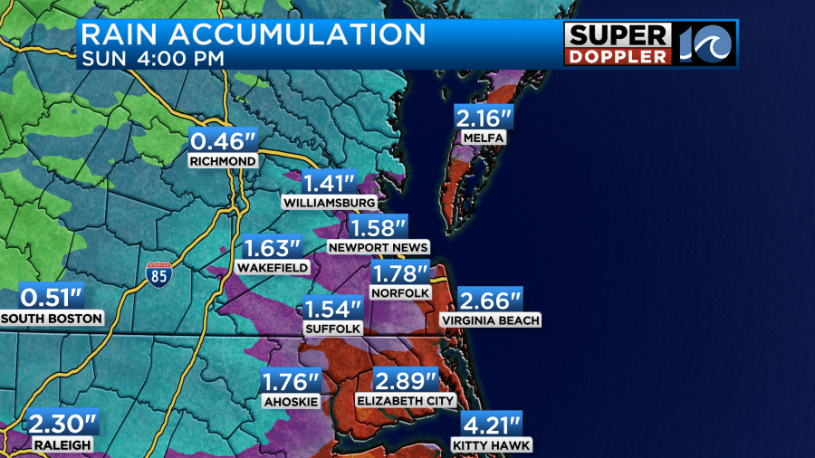
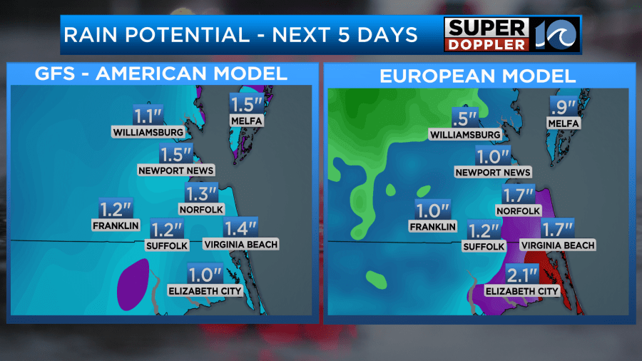
For rainfall I think we are looking at a solid 1-3″ with some areas getting 4″ or more.
Keep in mind that none of this will be from any tropical systems. Subtropical storm Karen formed yesterday over the northeast Atlantic. It will pretty much stay out to sea.

Tropical storm Jerry actually weakened since yesterday. This may have been due to some of the interaction with the Lesser Antilles, but it is more likely from some wind shear. The forecast for Jerry has it weaker now as well.

This is good news for Bermuda. They may still have some direct impacts, but the worst of the storm will definitely miss the island. It may mean that we’ll have a little less waves reaching our coast. We’ll see.
Meteorologist: Jeremy Wheeler


