Good Sunday morning. It is going to be a nasty day today with major tidal flooding, ocean overwash, gusty winds, and rain from a Nor’easter.
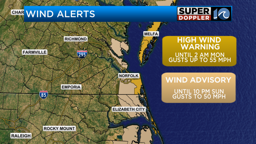
This strong area of low pressure will travel over the Outer Banks and right next to our shoreline throughout the day. Expect northeasterly winds gusting to 35 MPH inland and 40-50 MPH along the coast. Isolated wind gusts could be around 55 MPH. Virginia Beach and the Eastern Shore are under a High Wind Warning with gusts up to 55 MPH until 2 AM Monday. The rest of our coastal communities are under a Wind Advisory with gusts up to 50 MPH until 10 PM Sunday. These strong winds could cause power outages, blow loose outdoor items around, down tree limbs, and make it difficult for high profile vehicles to drive. There are already reduced speed restrictions in place on the Chesapeake Bay Bridge Tunnel (CBBT). These winds will also bring us some of the worst tidal flooding we’ve ever seen.
This storm will be comparable to the one we saw about a month ago on September 16, 2025. The flooding we saw then will be a little worse today. If you don’t need to drive around our coastal communities today, stay home and try to limit that travel around high tide. If you have to be out around high tide and come across a flooded road, turn around and find an alternate route. You will ruin your car’s engine trying to cross through flooded roadways.
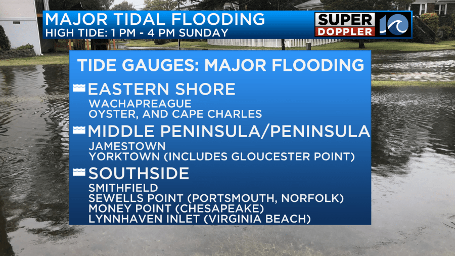
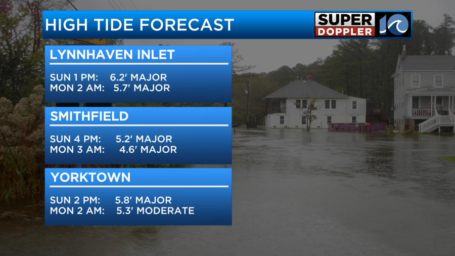
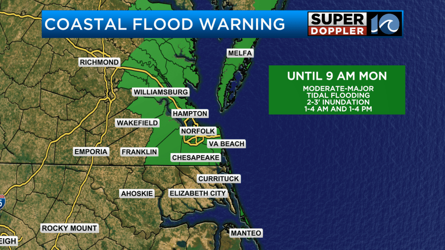
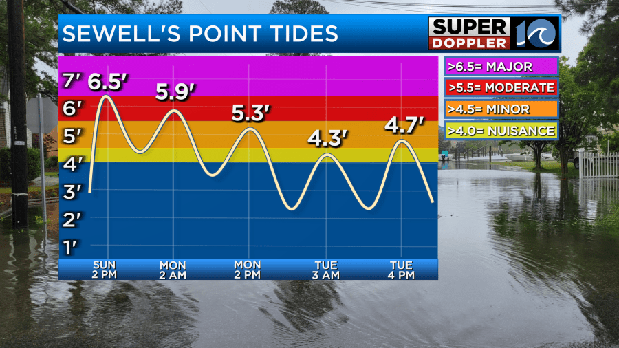
The worst of the tidal flooding will be at high tide this afternoon around 2 PM Sunday. A lot of locations will reach the major tidal flooding category with 2-3′ of inundation.
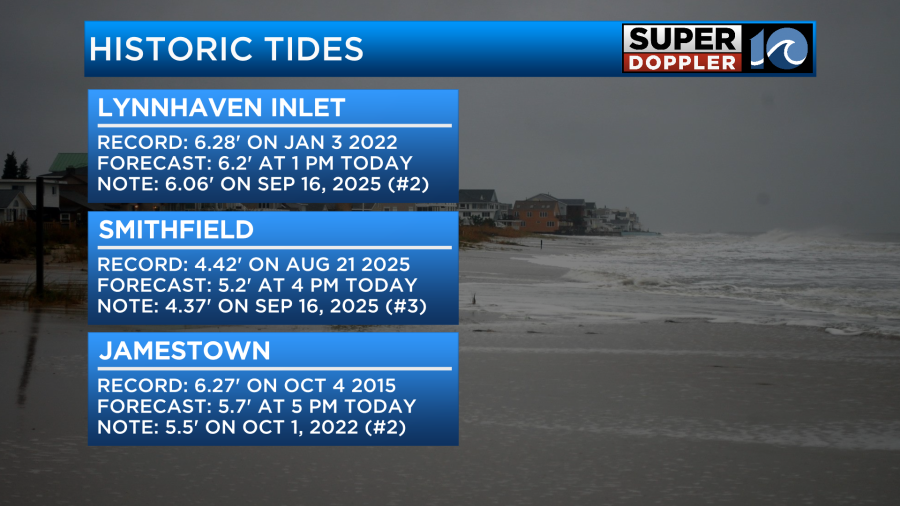
This could set or come close to a few records. At Lynnhaven Inlet, tides will be flirting with the record of 6.28′ set on January 3, 2022. The forecast is 6.2′ today. Smithfield will likely set a new record. The current Smithfield record is 4.42′ set on August 21, 2025. The forecast is 5.2′ today. In Jamestown, the top record isn’t in jeopardy, but the second spot is. The forecast is for 5.7′ today.
During our low tide this evening, we will still be dealing with tidal flooding in some locations as tides only drop to nuisance-minor flood levels. Then tonight, around 2 AM Monday, we will see tides reaching moderate levels, a few locations like Lynnhaven Inlet and Smithfield will return to major levels.
Our coastal communities are all under a Coastal Flood Warning until 9 AM Monday.
Tides remain elevated in minor tidal flooding ranges during the next few high tide cycles Monday and Tuesday as winds remain breezy.
Ocean overwash across NC-12 will also continue the next few high tide cycles. 10-15′ breaking waves today.
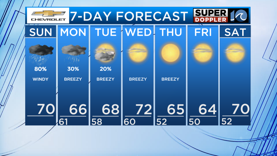
As for the rain with this system, a dry slot has developed in the middle of the storm. This means we’ll be a bit drier this afternoon and evening with just isolated to widely scattered showers. On the backside of this system, we’ll see another round of scattered rain Monday evening-night.
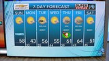
Following the coastal low, an area of high pressure in Canada will be entering our region. This transition period will keep winds breezy with 25-35 MPH gusts through Thursday. High pressure will bring us plenty of sunshine from Wednesday on and cool temperatures. Highs in the mid to upper 60s with lows in the 50s most of the week.
Be careful in this tidal flooding today!
– Meteorologist Kristy Steward