Luckily we didn’t have much rain during the morning commute today. There were a few showers north and south of the metro area. However, we will have an increasing chance for rain today. I’m looking forward to the rain. It’s been about 12 days since we’ve had rainfall. The trees and grass need some for sure. Plus…My car has a weird film on it, and I haven’t been able to wash it. So…
Today’s rain shouldn’t be too bad. A cold front will move through the region this afternoon, and there is a good amount of moisture in the area.

So we’ll have scattered rain showers forming between the mid-morning and the mid-afternoon hours.
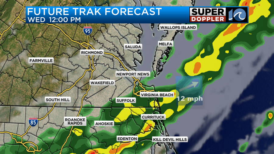
During the afternoon the actual front will move through the area. This will produce a broken line of showers with a few thunderstorms.
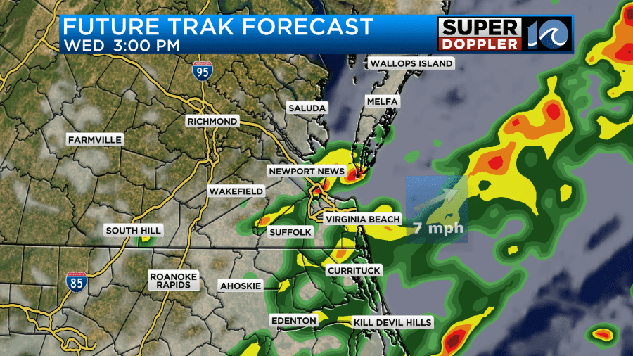
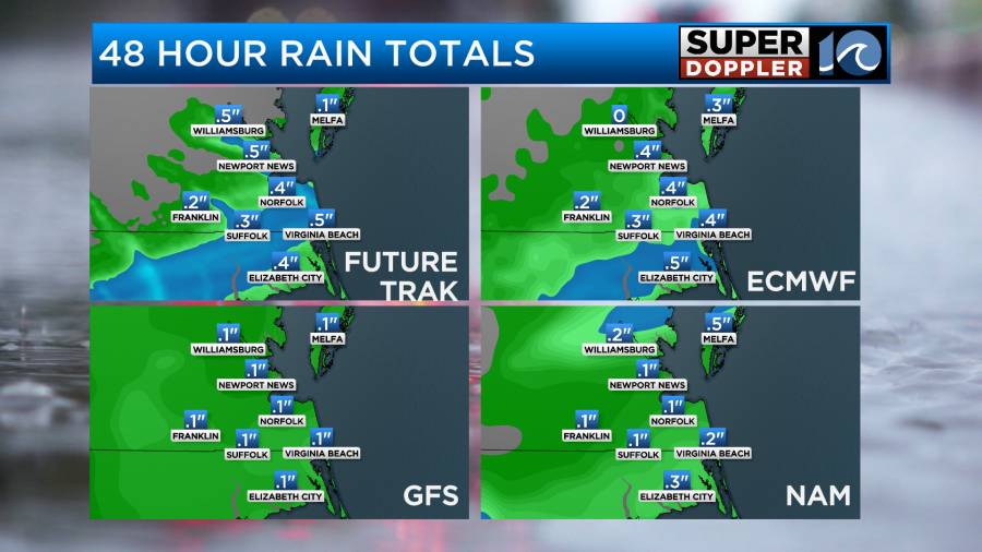
The rain should taper off quickly between the late afternoon and evening hours as drier air pushes into the region. Before it ends, we could pick up about a quarter to a half an inch of rainfall with some isolated spots possibly getting just under an inch.
Winds won’t be too bad. They will be out of the southwest and then northwest at 10-15mph today. There will be a few gusts to 20mph. High temps will be able to warm up to the mid-upper 70s before the front slides through.
Drier weather will pour in from the north tonight. Then we’ll be much cooler and drier on Thursday and Friday.
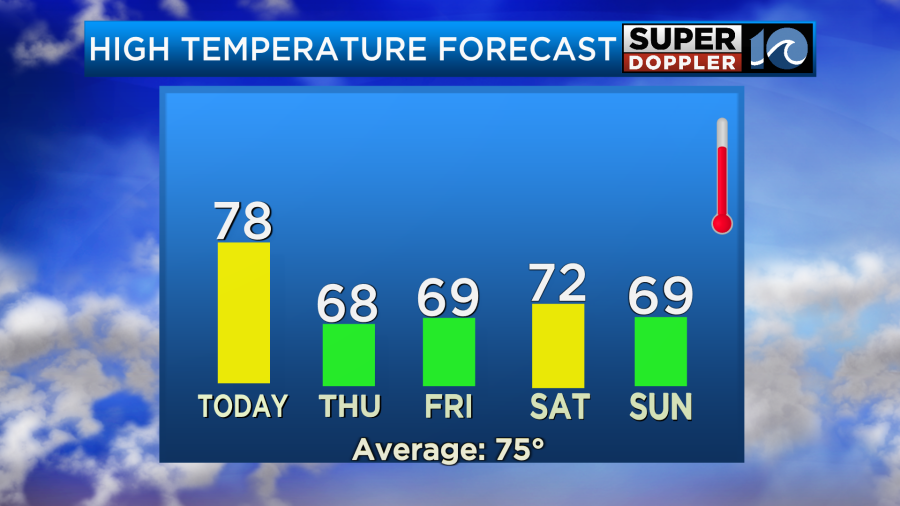
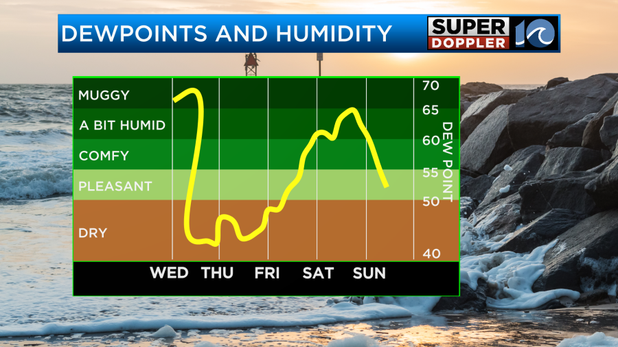
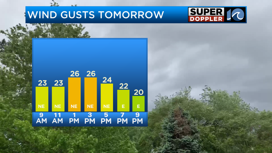
Dew points will drop below 50 tomorrow, and it will feel great. It will be breezy though with gusts up to 25mph out of the northeast.
There may be some nuisance to minor tidal flooding tomorrow and again on Friday.
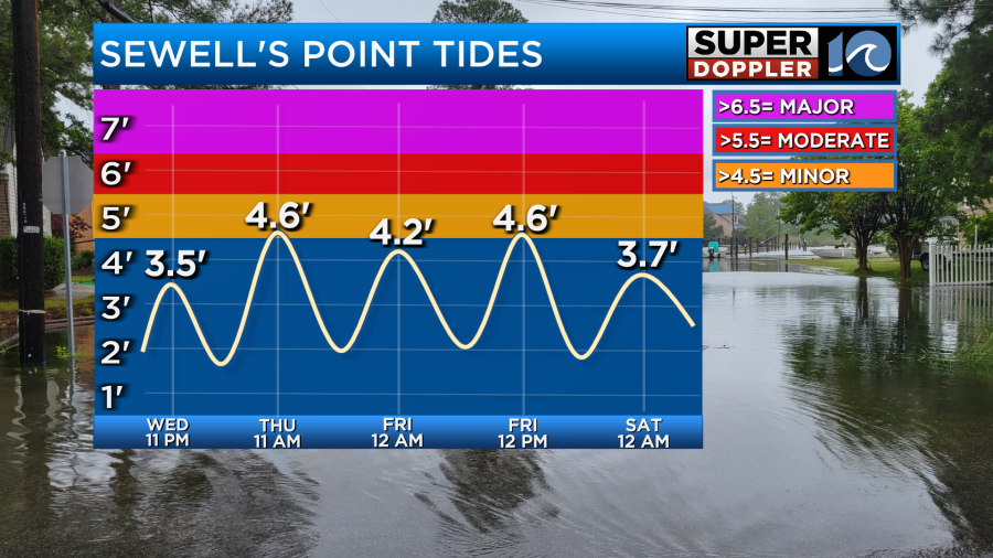
The winds will stay out of the northeast through that time creating a little tidal flooding. However, that tidal flooding may increase dramatically by the weekend.
There is a tropical storm out over the Atlantic. Jerry formed yesterday, and it is on west/northwest track. However, that system is expected to stay offshore.
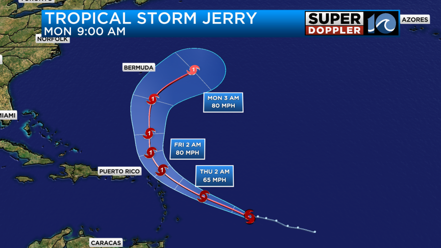
The latest forecast even has it tracking east of Bermuda in a few days. The models are in fair agreement about this. Despite staying offshore, I do think it will send some more high waves our way. That’s been very common over the last couple of months. It is expected to become a category 1 hurricane.
So there is another non-tropical feature that is supposed to affect us this weekend. By Friday the cold front will have stalled out to our south. An area of low pressure will form along the front. That area of low pressure will creep north on Saturday. It will still be to our south, but it is forecast to push a lot of moisture up into our region.
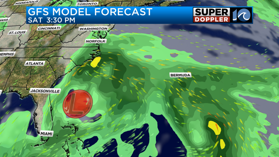
For now the forecast calls for scattered rain showers as we go into the afternoon. We’ll see how far north that rainfall gets during the day. We’ll have a better idea about that part of the forecast when it gets more in range of the NAM and Hi-res models. There may be some breeziness, but it doesn’t look too bad. However, the trend is for increasing rain and wind on Sunday as the area of low pressure drifts offshore.
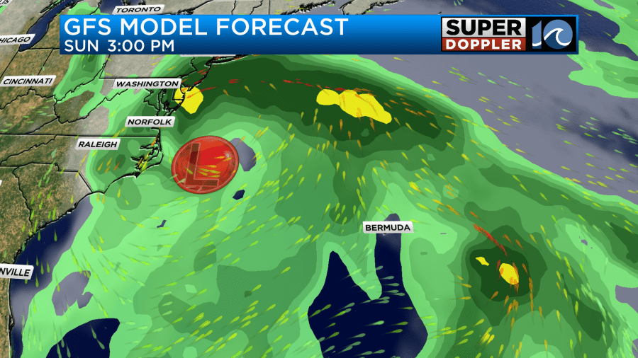
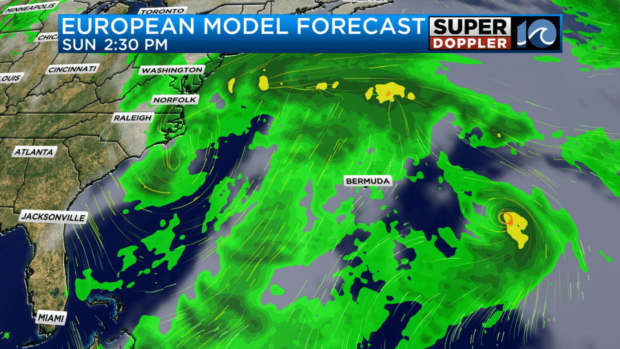
The models are in agreement in terms of a strengthening offshore low. However, they disagree on the exact placement. This is impacting where the strongest winds will be. Here is a look at the wind on Sunday from the GFS model.
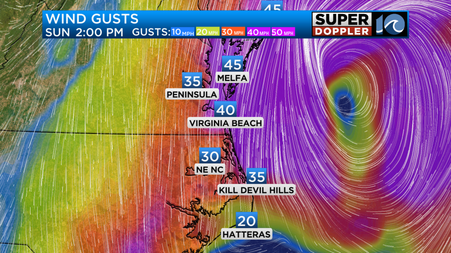
Keep in mind that early this morning it had winds gusting to around 50 mph over the Outer Banks. Now it has the stronger winds on the Eastern Shore. Regardless, I do think we’ll have strong coastal winds. Gusts will possibly be to around 30-35mph in the metro with higher gusts near the shore. We should be able to pinpoint the rain, wind, and tides much more by tomorrow. So check back for updates.
Just note that there could be some more beach erosion and overwash across the Outer Banks this weekend. Especially since a lot of the beach and dunes have already taken a beating this season. Stay tuned for updates.
Meteorologist: Jeremy Wheeler


