Friday Evening Update:
Alright — the latest information coming into the weather center keeps the forecast promising for snow across most of the region. However, this will be a fast moving system, so it could be moving out right around sunrise tomorrow morning.
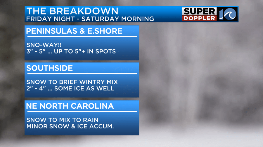
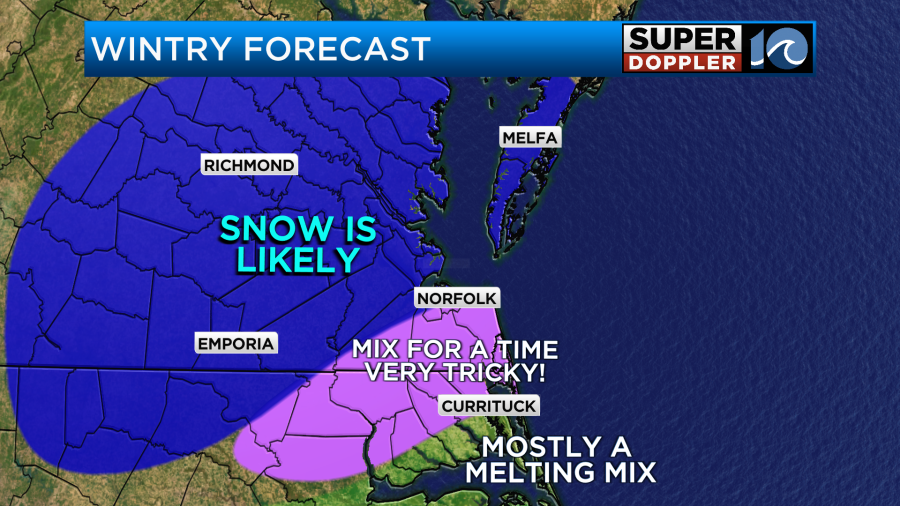
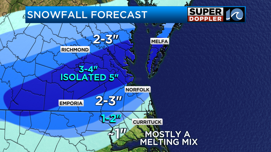
Across the Peninsulas and the Eastern Shore — this does look like an all-snow event! Snow moves in late tonight and carries over to early Saturday morning. It’ll come down heavy at times through the night, so we’ve bumped up snowfall totals… snow totals could be up around 5″+ in some spots!
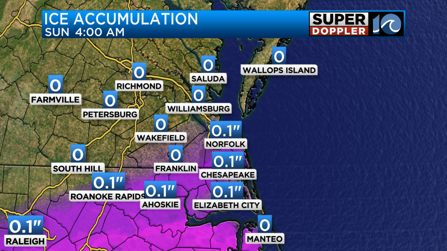
On the Southside, snow starts up late tonight and continues through most of the night, but by early Saturday morning there will be a brief wintry mix that could slick things up and limit snow totals. Still, that brief wintry mix will be, well, brief. So with it not lasting all that long, any rain or ice mixing in won’t have much time to wash things away. Maybe around 2 to 4 inches, with some minor ice here or there.
Then along the state line and into northeastern North Carolina, things start up with snow first, then flip to a mix overnight, the flip to rain early Saturday morning. So snow totals won’t be much, with minor ice accumulations as well.
Again, the storm system moves out very quickly and we’ll look forward to sunshine peaking out by the afternoon hours. It turns clear and cold Saturday night, so be wary of any slick spots due to refreezing come Sunday morning. It’ll remain sunny and cold from Sunday through most of next week.
Check the rest of Jeremy’s weather blog below — there’s a whole lot more info for ya there.
-Steve
______________________________________________________________________________________________________
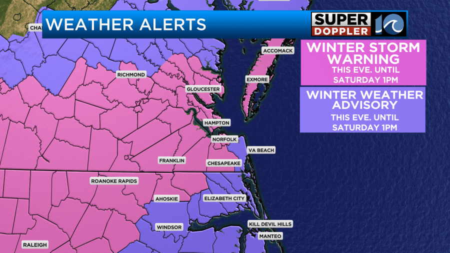
It’s always tough to do the forecast the day (or morning) before snow is expected. The day that it’s happening is actually pretty fun. The forecast is done. So you are just now-casting (very short term). You get reports. You get photos. However, the day before is when you have to try and make that all-important SNOW TOTALS FORECAST. The last event we did a pretty good job. However, there was a lot of melting in the metro area. This time we have a pretty good shot at accumulating snow. However, the forecast will be very tricky for one area due to a developing zone of wintry mix. There are already weather alerts for the area.
Let’s Talk about it.
This morning we had high pressure in the region with an area of low pressure off to the southwest.
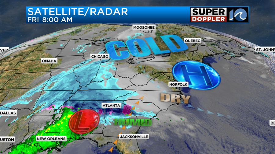
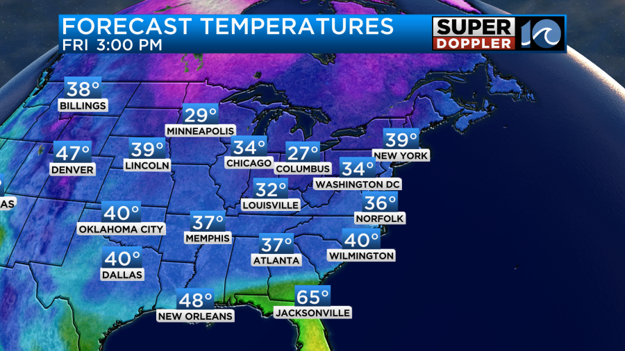
Both were moving east rather quickly. During the day today we’ll have increasing clouds. High temps will rise to the mid-upper 30s.
We’ll be dry all day, and probably through the evening commute. By the later evening the moisture will increase quickly. There will still be some dry air at the surface at first, but it will be quickly overcome by the moisture. Scattered snow showers will push in from the southwest.
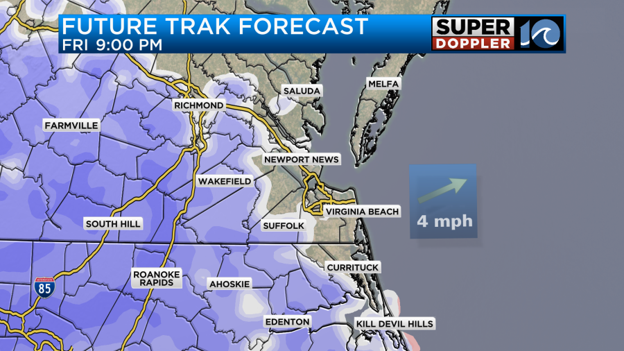
It may show up as virga for a bit before 8-9pm, but then it will start to reach the ground. It also may very briefly fall as a bit of a wintry mix. However, the precip will quickly transition over to snow showers. It will probably start as a snowy mix over the Outer Banks, but that area will then change over to rain showers during the overnight.
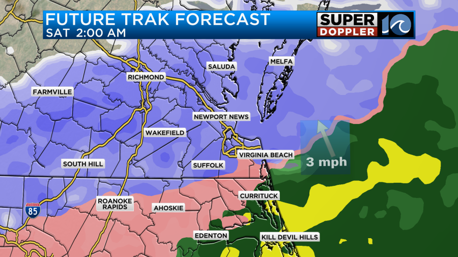
The rain/snow line will work up towards the state line, but the bulk of southeast Virginia can expect snow showers. It could even be briefly heavy. By early tomorrow morning the rain/snow line is forecast to lift a little more to the north. This could even make it as far north as central or northern Virginia Beach.
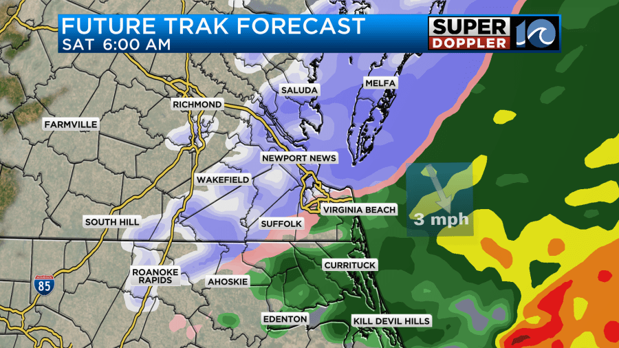
Snow showers will be falling for the rest of southeast Virginia, but there will be more of a mix of sleet, rain, and some freezing rain over coastal North Carolina. If that zone gets up into the Southside, then that will decrease the snow totals. It could also allow for some iciness in that zone.
The area of low pressure will quickly move offshore by the mid-morning. The precipitation should wrap up between about 7 and 9am.
It could possibly end as a wintry mix, and there’s still one or two models that have a little (very brief) rain at the tail end.
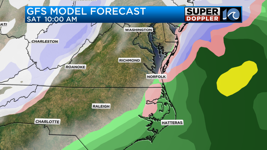
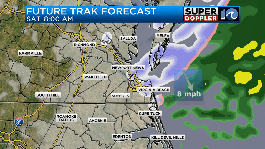
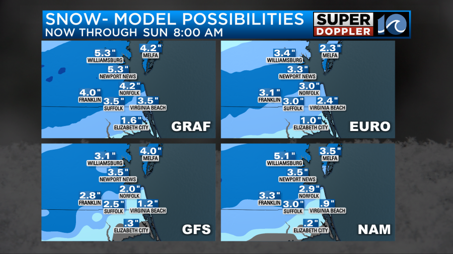
Here are the latest forecast models that I have. They all show a large swath of 2-3 inches with some higher amounts north of the metro. They all show lesser amounts to the southeast.
The tricky part is that mix zone and how far north it gets.
Future Trak is not alone in bringing the wintry mix up into the Southside. The hi-res NAM has that zone almost up to Hampton and Kiptopeke for a brief time. This “mix” would likely be a combination or sleet, rain, and freezing rain. There could also be some general (cold rain) for a time that could cause a little melting. So having said all of that…Here is my snow forecast map:
Here’s a closer view:
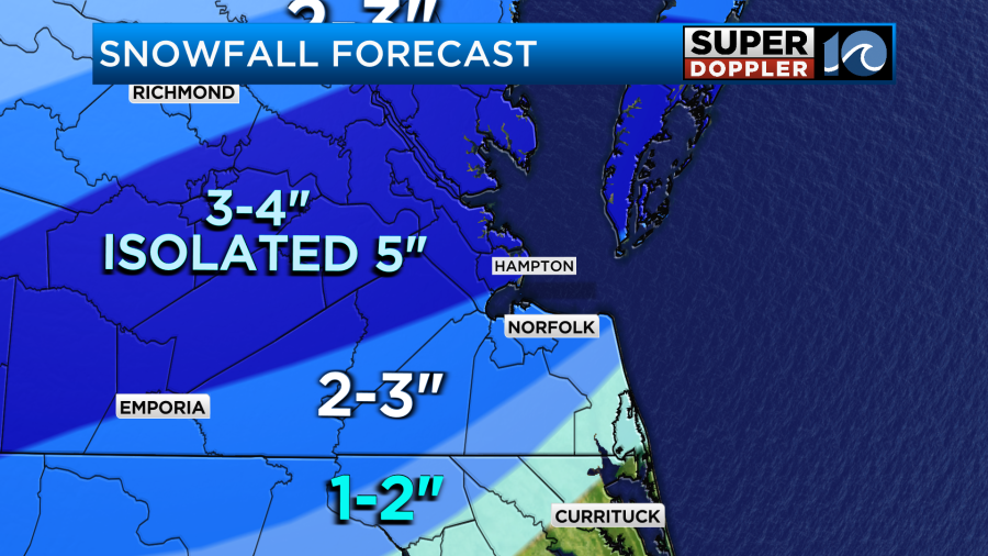
I’ve put together a blend of all the models. It’s possible that if the system moves faster, then the totals may decrease slightly. It’s also possible that the system could slow down a bit. Though I doubt a slower trend will happen due to its current speed. Another possibility is that the broader moisture hangs around and allows for some decent precip on the back side of the low. So that could increase the totals a bit. Especially in that swath of 2-3″. The good thing is that the models are starting to get into some agreement on the totals and the theme (more north of Hampton Roads and much less to the southeast).
There will be some problems on the roads tomorrow morning. There will be some melting tomorrow as high temps rise to the low 40s, but that will take some time.
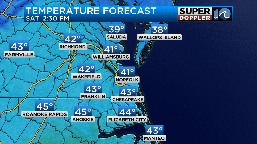
One problem from that will be that the temps will drop back down to the 20s Saturday night. So there will be a re-freeze of the meltwater into Sunday morning. At least we’ll warm up again in the afternoon. We’ll have quiet weather on Sunday. High temps will be near 40 with fair skies. Stay tuned for updates on all of this weather. Hopefully, folks will get to enjoy at least some snow tomorrow morning. Be safe on the roads though.
Meteorologist: Jeremy Wheeler