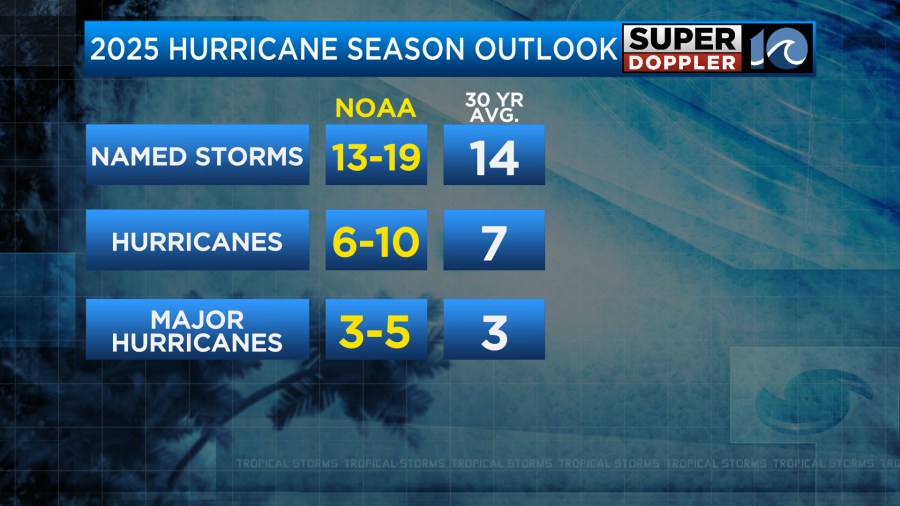
(WAVY) — The 2025 Atlantic hurricane season is officially underway and forecasters are predicting a slightly above normal season. While this forecast is a sign that we need to be ready for whatever comes our way, it’s also important to also know that it only takes one to make a big impact.
In order to get ready for what’s to come this season, let’s take a look back at some of the most impactful storms to hit Virginia and North Carolina in recent memory. We will start with Hurricane Isabel back in September 2003.
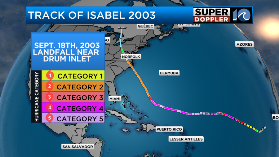
Isabel was the ninth named storm of the 2003 season, and it had a very long track, starting out as a tropical wave off the coast of Africa. At peak intensity, Isabel was a monster Category 5 hurricane a few hundred miles southeast of Bermuda, with maximum sustained winds of 165 mph. As the storm continued moving west across the Atlantic, it weakened down to a Category 2 storm, with sustained winds around 100 mph.
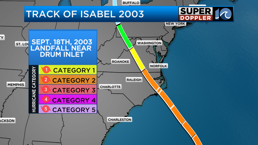
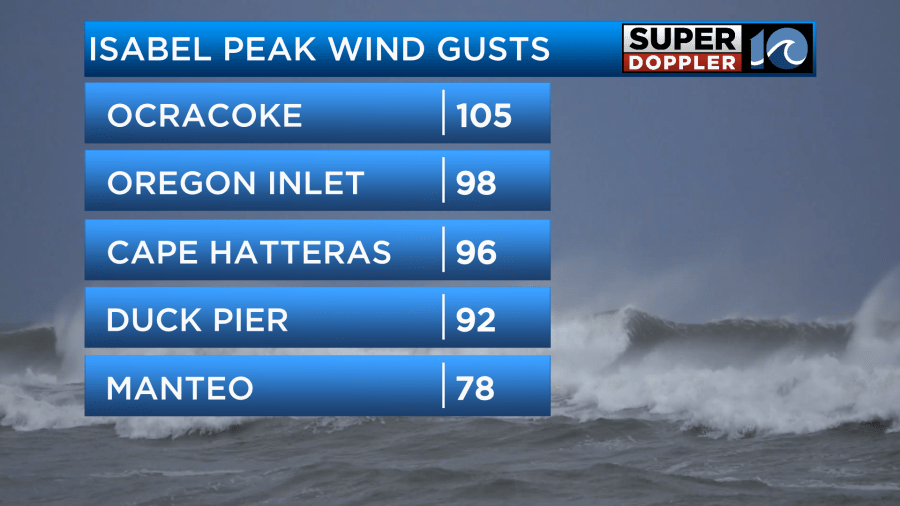
Isabel eventually made landfall near Drum Inlet in the Outer Banks of North Carolina during the early afternoon hours of Sept. 18, 2003. One of the top impacts as the storm came ashore was wind, as parts of the Outer Banks gusted over hurricane force.
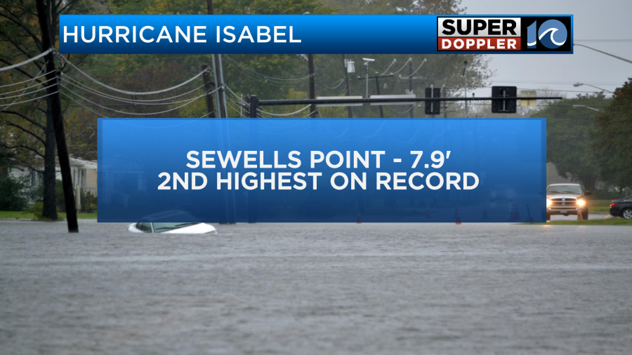
Another impact was the storm surge across coastal North Carolina and southeastern Virginia. Since the storm made landfall to the south of our region, onshore winds on the northeast side of the hurricane piled up water into the Chesapeake Bay, which is connected to other major waterways.
This push of water into our coast caused extensive damage to property and even fishing piers across the region including the 15th Street pier in Virginia Beach. Additionally, the Midtown Tunnel between Norfolk and Portsmouth was closed due to flooding, as the water levels rose to near-record levels at Sewell’s Point.
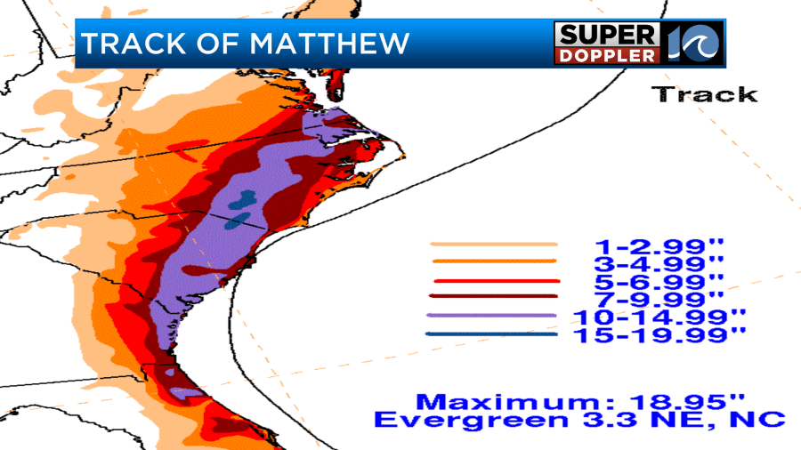
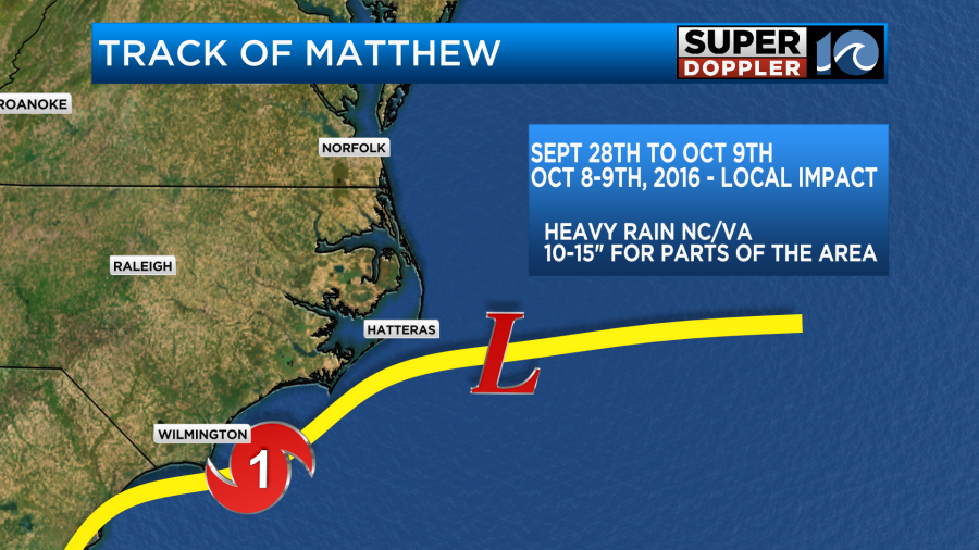
Now let’s talk about Hurricane Matthew, which was a highly-impactful storm across Hampton Roads for a different reason — the torrential rainfall.
After forming near the Lesser Antilles, Matthew gained strength over the extremely warm waters of the Caribbean Sea. At its peak intensity, the storm reached Category 5 status before turning north towards Florida. Once off of Florida’s east coast, it was a very close call, as the center came within 30 to 50 miles from the coastline.
As the storm continued north into our region, on Oct. 8-9, 2016, it slowed down and interacted with an incoming cold front, which made the rainfall threat even greater. Across Hampton Roads, rainfall amounts reached more than a foot in some areas, causing widespread freshwater flooding.
Finally, we have Tropical Storm Isaias, which was a part of the hyperactive 2020 Atlantic hurricane season, which resulted in 30 named storms. This broke the record for the most amount of named storms in a single season surpassing the previous record of 28 set back in 2005.
Tropical Storm Isaias took a south-to-north track, with the center of the storm going over inland areas towards Interstate 95. This meant that the right-front quadrant of the system was passing over Hampton Roads. This quadrant is where tornado formation is most common due to the combination of the storm’s forward speed and counterclockwise rotation. Additionally, this part of the storm is where there is the most wind shear or spin in the atmosphere as you go up in the air.
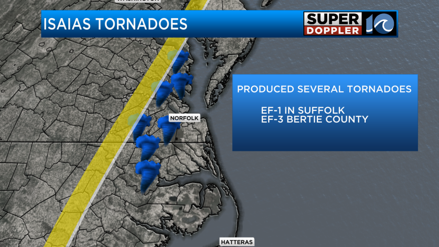
Two of the most well-known tornadoes during this storm were the EF-3 tornado in Bertie County, North Carolina, as well as the EF-1 in Suffolk, which caused damaged to the downtown area.
So the question remains, what can we expect for this hurricane season? With warmer-than- average sea surface temperatures across much of the Atlantic basin and the El Nino southern oscillation leaning more towards a neutral state, forecasters say this could be a slightly above-normal season, but remember, it only takes one storm to make an impact.