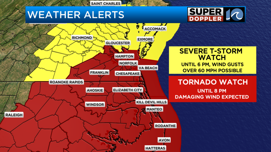
A Tornado Watch was issued for the majority of the region until 8 p.m. Wednesday. Damaging wind gusts were possible as the broken line of strong thunderstorms crashed into the region.
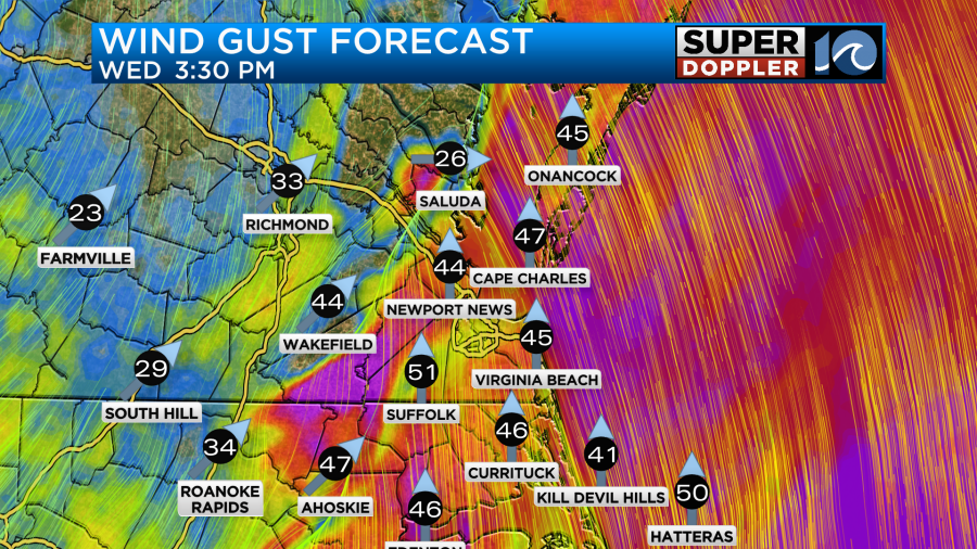
A Severe Thunderstorm Watch is issued until 6 p.m. Wednesday for the Middle Peninsula and the Eastern Shore. Wind gusts upwards of 60+mph are possible.
______________________________________________________________________________________________________
We are going to develop a very active weather day. Over the last 24 hours a strong area of low pressure has been developing over the Deep South. Now it is moving into the Midwest.
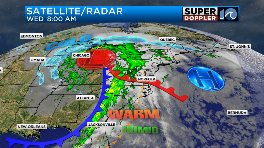
There are blizzard conditions north of that system today with more Spring-type storms to the southeast of it. The area of low pressure won’t move through our region, but a couple of fronts will. The first front has already moved into the area. It will be responsible for warming us up today. We’ll be in the warm zone during the day with the warm front lifting to our north and the cold front moving in from the west. Winds are going to be strong all day, but they could be severe during the afternoon.
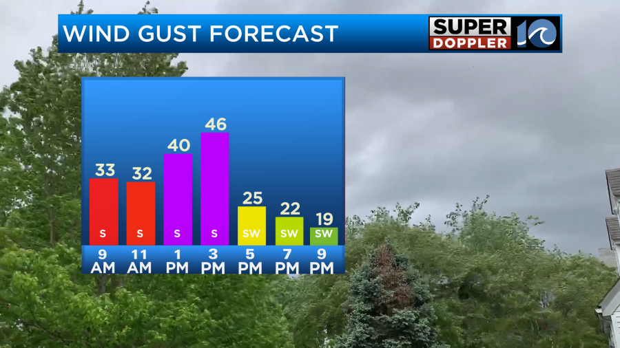
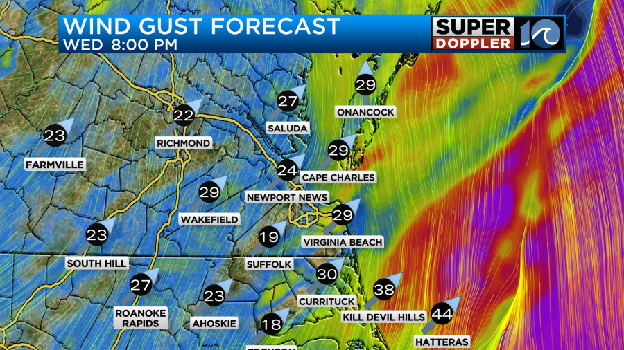
The general wind will be strong anyway, but severe winds will be possible by the mid-afternoon. Winds will gust between 35 and 45mph from the late morning until the mid-afternoon. After that winds may gust even higher for a time as a line of storms arrive.
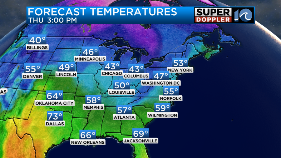
These strong winds will push our temperatures up into the low 70s despite lots of clouds through the day.
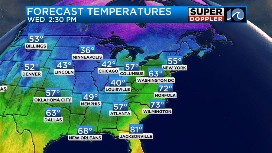
It will be cooler over the Outer Banks and the Eastern Shore due to the cool water temperatures.
By midday a line of storms will form east of the cold front. The models currently have the line forming just to the west of I-95 around midday.
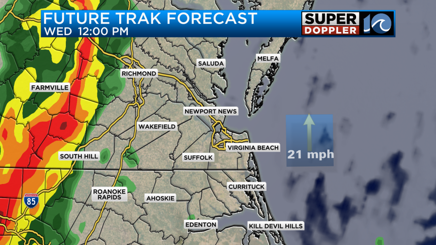
By the afternoon the line will be moving into the viewing area. At first it will hit our inland locations.
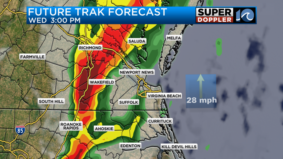
Then between 3 and 5 pm the line will slide through the metro area.
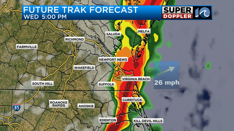
The storms should move offshore by about 6-7pm. Keep in mind that the line could speed up or slow down some. Either way winds should decrease after the line moves out to sea.
We have an enhanced risk for severe weather today for most of the region. That is a level 3 out of 5.
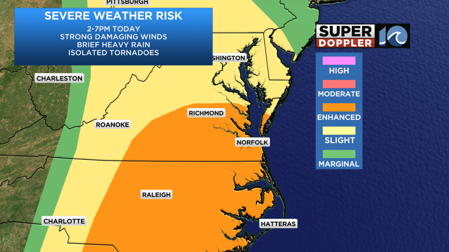
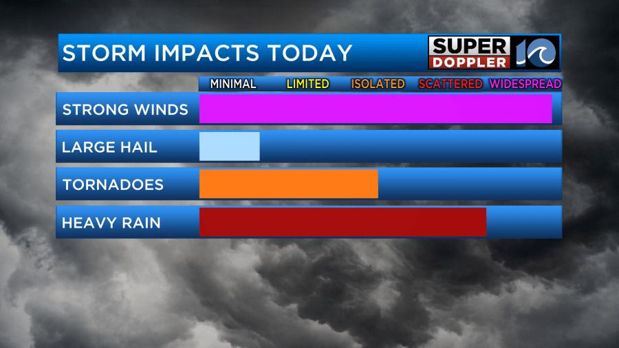
Strong/damaging winds will be the main threat. A low-level jet will push up out of the south ahead of the cold front. These intense winds that are up a few thousand feet could be transported down to the surface as heavy rain and sinking air pull that force down to the ground. This low-level jet will also create a lot of wind shear. Wind shear can physically pull air upward. Which is what thunderstorms need. It could be enough to overcome the low amount of instability today. That’s the air’s potential to rise. Warmer/humid air at the surface becomes unstable when colder air is aloft. However, the bulk of the day will have warm temperatures aloft. That is right up until the line of storms arrive. Then there will be a thin strip of colder air coming in (aloft). That’s probably why the line will be relatively thin. There will be some broad rotation in the atmosphere. This could be enough to create some isolated tornadoes.
Keep in mind that the actual cold front will lag behind the line. It probably won’t come through until about 10mph. There will only be some isolated showers overnight. A couple of these could linger into tomorrow morning but probably only until about 7am. Then we’ll be dry for the rest of Thursday. The wind will be out of the west/northwest. Gusts will be up to 25mph. This persistent wind could create some minor tidal flooding on the Sound Side of the Outer Banks. This could also happen to a degree on the bay-side of the Eastern Shore.
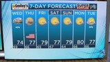
Regardless, we’ll be dry tomorrow with a mix of sun and clouds. High temps will drop to the mid-upper 50s.
We’ll be dry and comfortable on Friday and Saturday. High temps will be in the upper 50s to low 60s with partly cloudy skies.
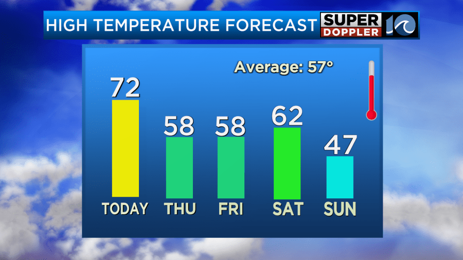
It does look like we’ll have an area of low pressure pass to our south on Sunday. The GFS brings a few rain showers up this way with a very brief mix possible. However, the European model still keeps the low very far to our south. So it doesn’t have any rain. I have a low chance for a shower for now, but I may take it out if the GFS trends towards the Euro. If the GFS is right, then there could be a very brief wintry mix in some spots. We’ll see.
Stay tuned for updates to all of this.
Meteorologist: Jerem Wheeler