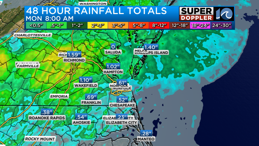
Yesterday, was definitely an active day. We had some strong wind gusts over the region. Winds gusted to over 50mph in some places. Small limbs and sticks had fallen all over the place. We ended up with about a half inch to an inch of rainfall.
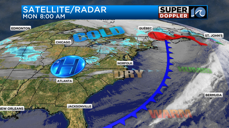
We warmed to the upper 60s and low 70s ahead of a strong cold front. Then temps slowly fell during the afternoon. Today, that cold front is pushing offshore. There is an area of low pressure in the northeast states, causing more snow up there. High pressure is to our west.
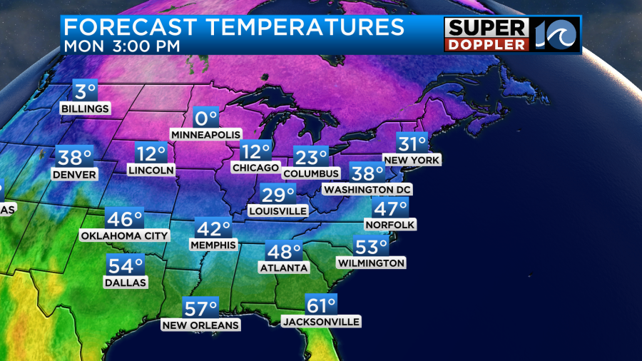
High pressure will build east today. That will provide us with lots of sunshine. It will be a little breezy, but nearly as bad as yesterday. Gusts will be up to 20mph this morning. It should calm down later today. High temps will rise to the mid-upper 40s this afternoon.
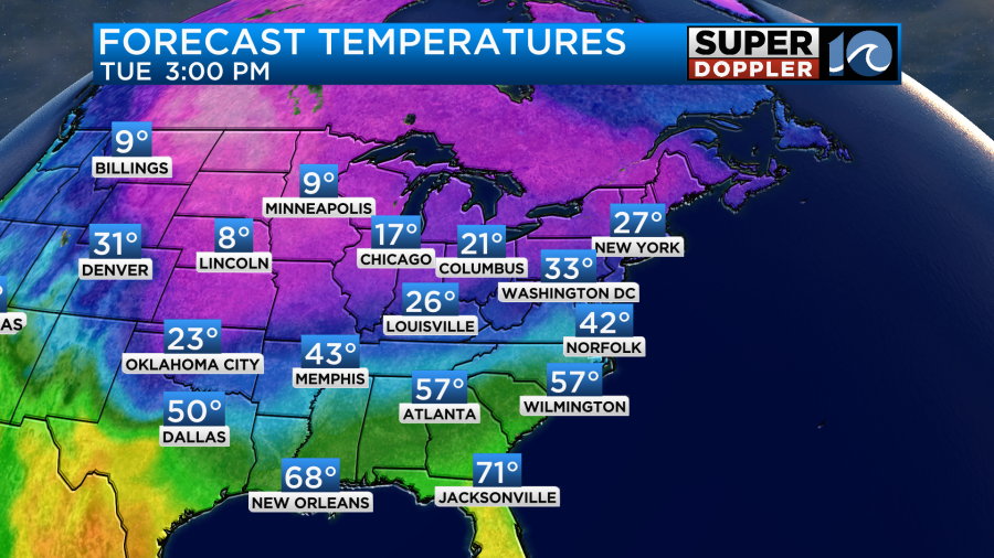
So we’ll have quiet/chilly weather here today, and it will stay quiet tomorrow. On Tuesday, high pressure will still be in control of the weather. We’ll have a little more clouds, but we’ll stay dry. We’ll have a light northeast wind. Low temps will be in the low 30s with 20s inland. High temps will aim more for the lower 40s.
Things will get very interesting as we head into Wednesday. During the day, an area of low pressure will likely form near the Gulf. It will then strengthen and run up along the Southeast coast.
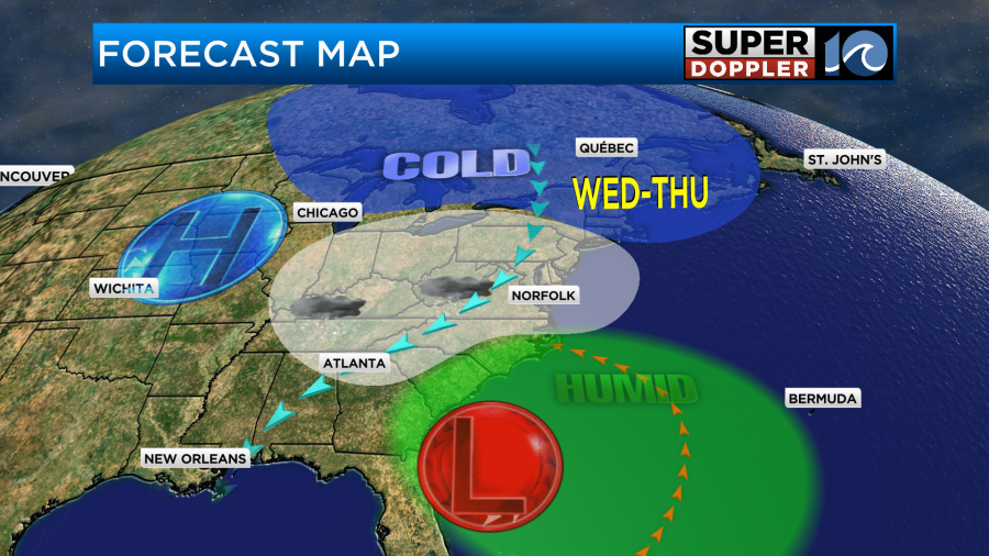
It will force a lot of deep moisture up into an already cold air mass. At the same time there will be a large upper-level trough overhead.
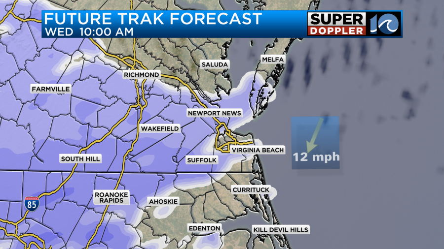
Future Trak has a few snow showers starting up by later Wednesday morning, but it kicks things into high gear by midday.
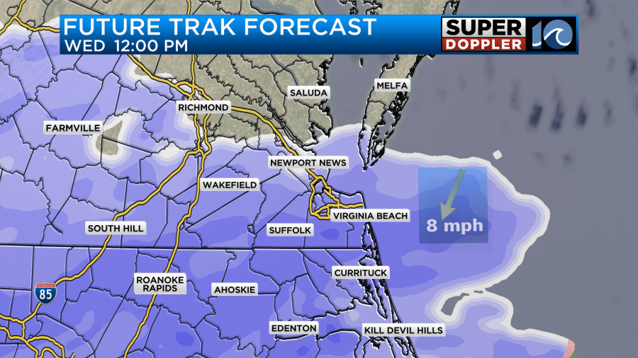
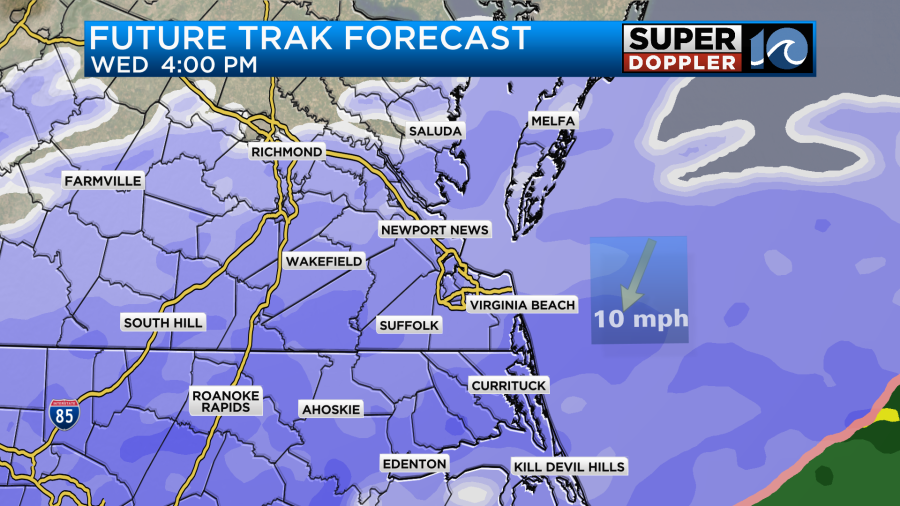
It then has (pretty much) snow for the entire area Wednesday afternoon into Wednesday evening.
The model cuts off at that point. So let’s look at the GFS and European models. Both the GFS and Euro have a lot of snow from Wednesday night into Thursday morning.
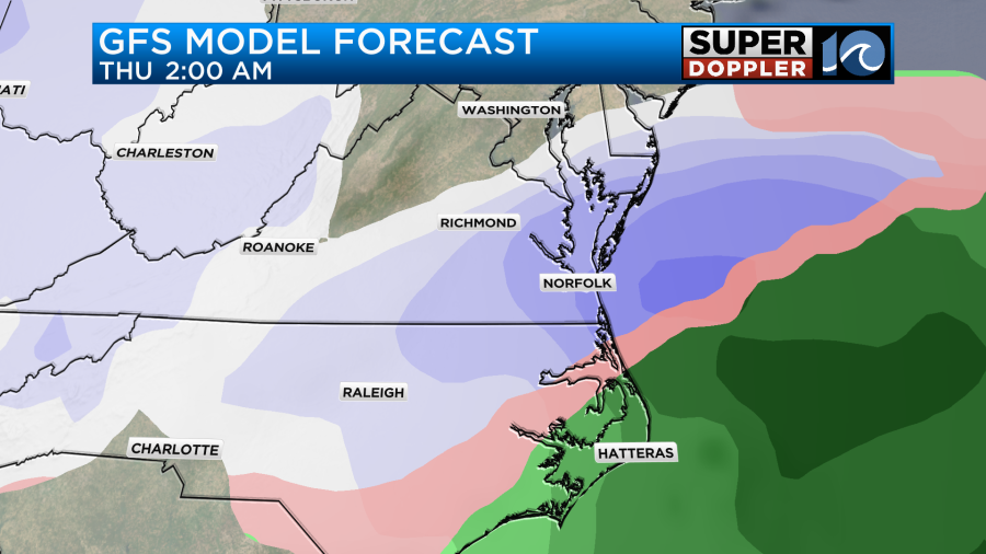
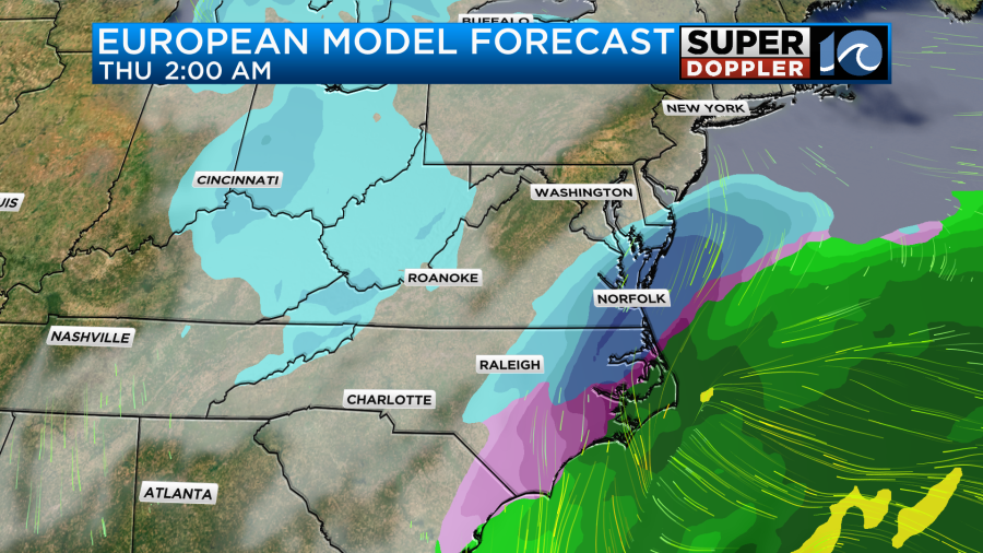
You’ll note that they do have rain and a mix for parts of coastal North Carolina, but that is it. The GFS spreads the snow out farther north. The Euro has a large band of heavy snow north of the rain/snow line. Course that is right over our viewing area.
They all have the low pushing offshore by Thursday. They have the snow wrapping up generally by midday, but they also have a few flurries in the afternoon. That would probably be as a pocket of energy comes through at the mid-levels. That probably wouldn’t add much to the totals. Having said that … look at the snow forecast. First off this is our Future Trak model.
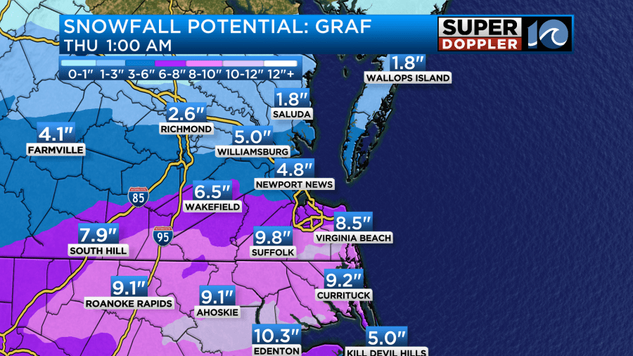
Keep in mind the cutoff time. This does not include all of the snow that is expected to fall. That is due to its high-resolution. It takes a lot of power to generate it, and so it can only go out so far. The Hi-res NAM is the same. Anyway, even with that time cutoff it still has a high amount of snow. Here are the GFS and Euro models.
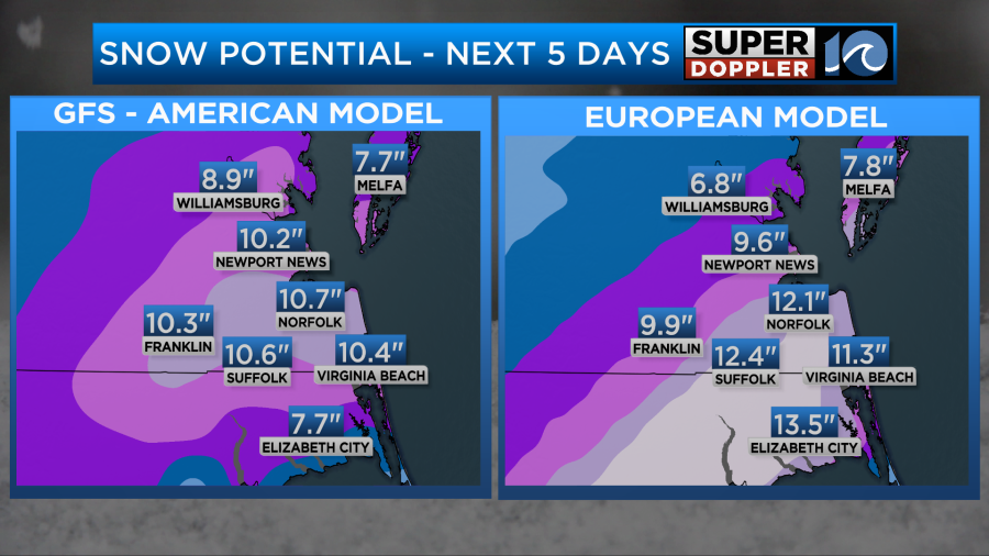
Yes … that is a foot of snow on the Euro model. The NAM has high amounts too.
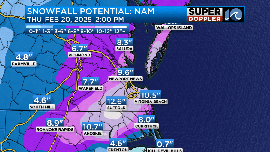
It does have a mix and some rain for coastal North Carolina for a time. So it has much lower amounts there.
I’ll show you the latest National Weather Service forecast, but please keep in mind its cutoff time as well (7AM Thursday).
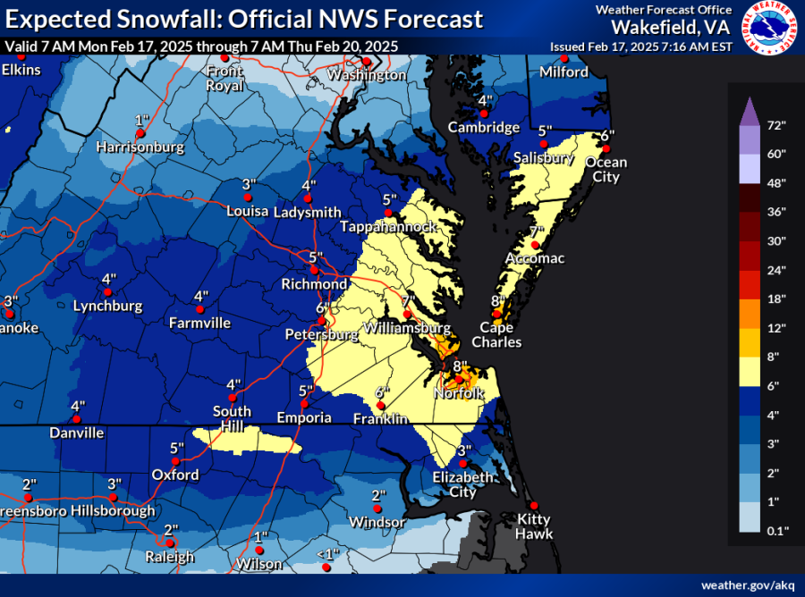
Hence, it also does not include all of the snow for this time frame yet.
Wow! So as I read the tea leaves I’ll say that it looks like our region will see amounts that will at least cause lots of problems if not shut down the area. High temps will be in the 30s both days.
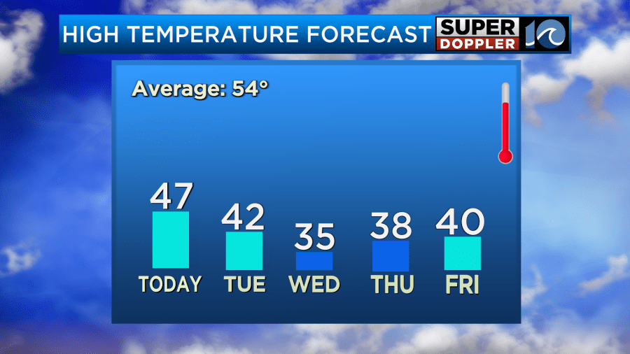
However, low temps will be in the 20s Wednesday and Thursday, and I may have to lower the high temps. It is possible that those numbers hold, and that a small amount of melting happens. However, this will not be like the last few events. Temps would be cold enough for the snow to stick. It would also stick around for a while. Possibly for 3-4 days. I have highs near 50 on Sunday. Until then I don’t think there would be a lot of melting. Even though there will probably be a lot of sunshine Thursday and Friday.
Here’s some general thoughts about the forecast. Number one… the low looks like it is going to be moving very fast. That speed may be difficult for the models to handle. If it zips through faster, then that could lower the totals (a little). It’s still possible that a wintry mix could get a little more north putting it closer to the Hampton Roads area. That is what some of the models showed yesterday, and they could possibly go back that way by tomorrow. However, the snow to liquid ratios could also be higher as there will be a lot of moisture contents. So that could possibly INCREASE the totals some more. If some of the higher totals verify, then it could be the biggest snow that we’ll have had since 2010. It will definitely be on par with 2018 which was what I’d call the last big snow. Here’s a link to the NWS climate for biggest snowfalls of all time: Top 10 biggest snowfalls in Norfolk.
My gut says that the numbers may come down a little, but not much. The models tend to go big about three days out. Then they start to factor in the local dry air and surface temps. We will probably be above freezing on Wednesday. So there could be some brief melting. However, the increasing snow would likely overcome that. There is still a lot of time for this forecast to change. However, since every source I am currently looking at has a high amount of snow it warrants a little early caution and alerting.
We have plenty of time for updates, but I would start prepping some in case the worst-case scenarios happen. Stay tuned.
Meteorologist: Jeremy Wheeler


