I knew the forecast was still going to be tricky this morning when I got in, but I had hoped that the models would be in pretty good agreement by 5am. Well…They agreed…somewhat. The trend is going pretty good, but the details are still shuffling around a bit. Let’s start with the setup today. We have a stationary front to our south with a weak area of low pressure along it. High pressure is moving offshore. There is a cold front over the Midwest.
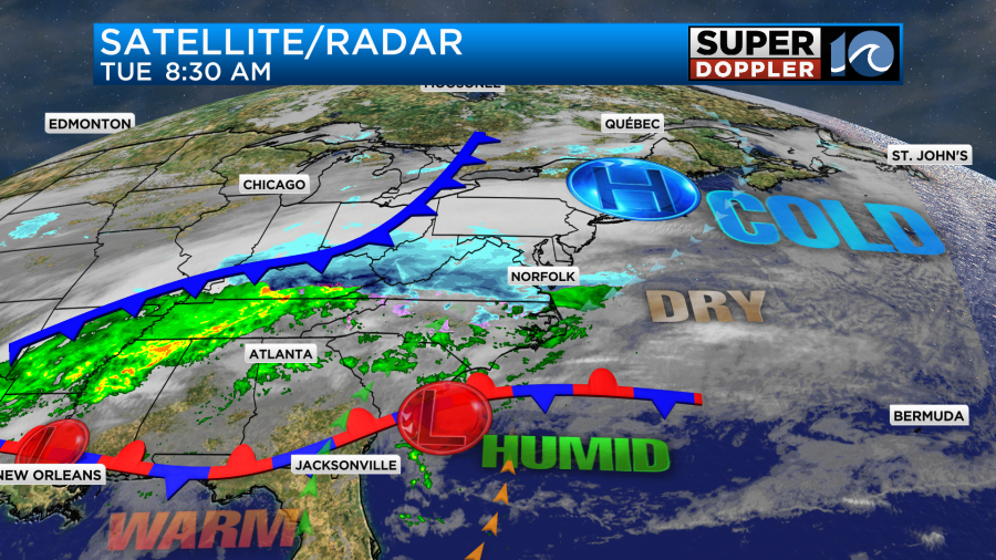
You’ll notice that there is a lot of activity where there are no surface features. This is due to overunning precipitation. This has been happening a lot this Winter, and it’s in full effect today. Basically warmer/more humid air pushes up over a cooler/drier air mass. This forces the air to rise and condensation to occur. Then precipitation will form and fall.
The precipitation had started up inland around 7am. Some light precip started in the metro around 8:30.
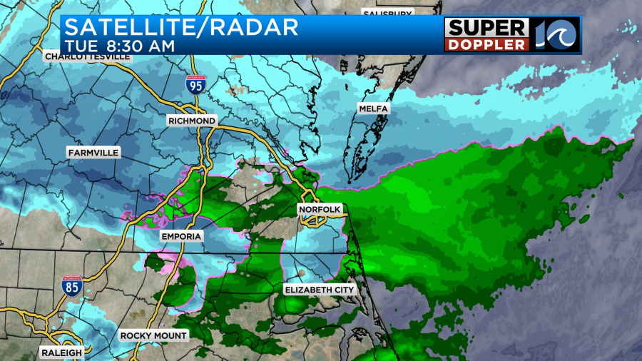
Moisture will continue to increase through the morning. The area of precipitation will grow by midday and the early afternoon.
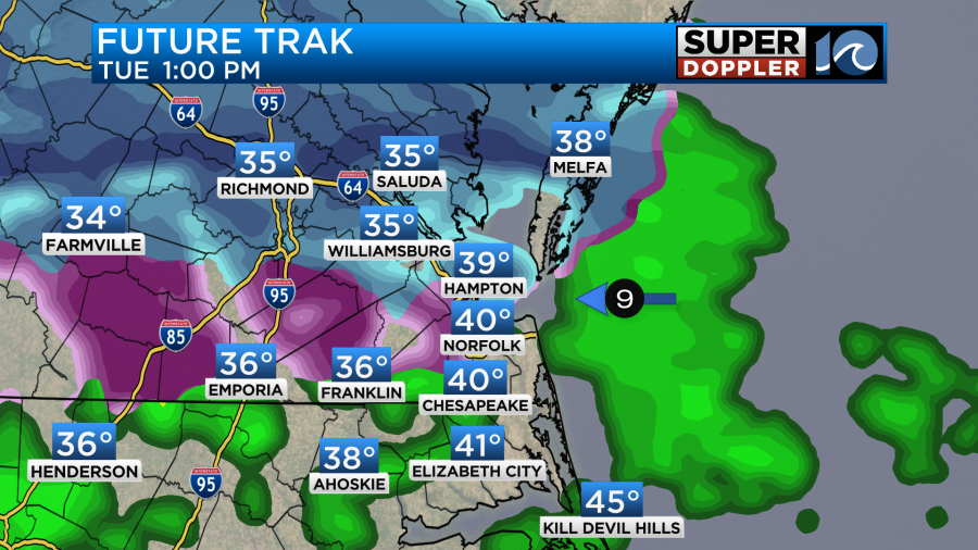
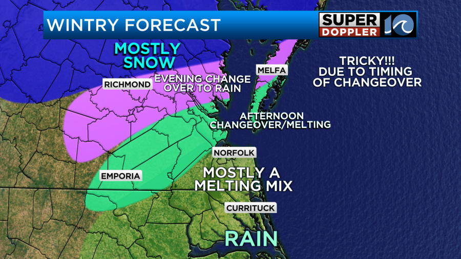
This will be a wintry mix in the metro with mostly rain over northeast North Carolina. There will probably be snow showers north/northwest of the metro by that time. Temps will probably fall as A. the snow falls and works on the temperatures and B. cold air gets dragged down with some isolated heavy precipitation.
So there will be some snow showers north of Hampton Roads this afternoon. However, at the same time the rain/snow line will be working its way north.
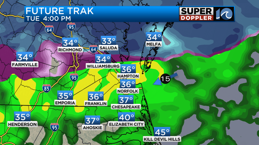
The rain will then cause melting to happen in that zone. Temps will be above freezing for much of the region except for areas north where the snow is falling. Temps may get close to the freezing mark there for a time. The rain/snow line will probably make it to the Northern Neck and Accomack county by the early evening.
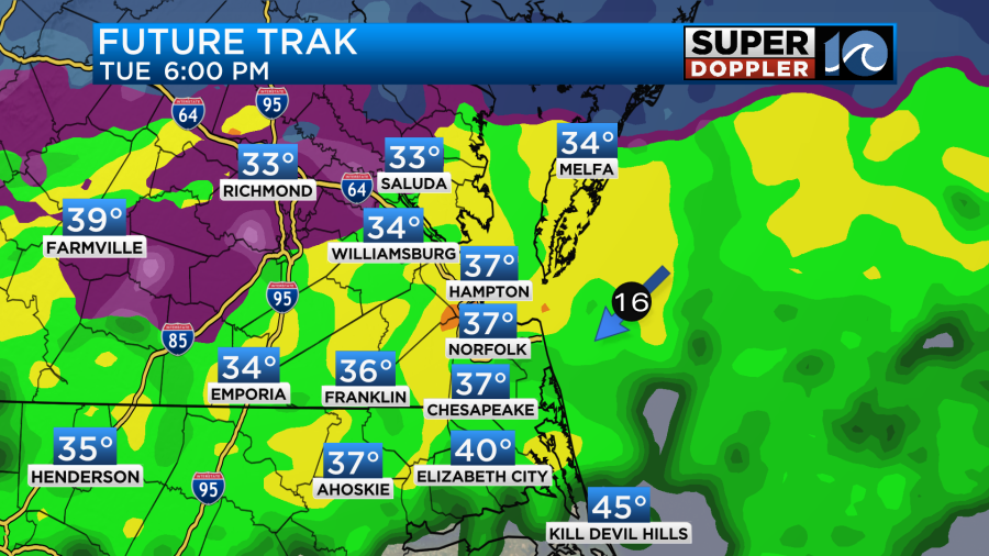
The models suggest that it will all rain by the later evening. Winds won’t be a factor today. We’ll have a steady northeast breeze at 8-12mph. High temps will be near 40 with upper 30s to the north. Tonight the rain will continue. It will be a cold rain with temps holding in the mid-upper 30s.

There will probably be some sleet mixing-in at times. Then more rain is expected for tomorrow as a warm front stays to our south but gets closer.
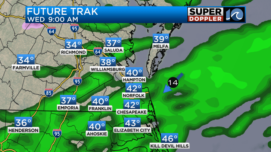
Rain may be heavy at times. There may be a few sleet pellets mixing in at times between tonight and tomorrow morning. Then more rain is expected on Thursday, but at least we’ll warm to near 60. We’ll be dry with highs in the 40s on Friday.
The snowfall forecast is still very tricky. The reasons are that 1. Temps will be above freezing for most of the area and most of the day. And 2. The timing of the rain/snow line marching north is a little different with each model.
Here are 4 of the models’ snow forecast.
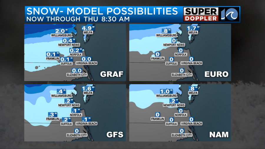
Our Future Trak model still has the most out of those 4. The hi-res NAM (not shown) really has hardly any snow accumulations in the metro area. You will notice that the highest amounts are from the Peninsula northward. This includes Accomack county. This is likely due to the rain/snow line taking longer to move up that way. Here is the National Weather Service’s forecast.
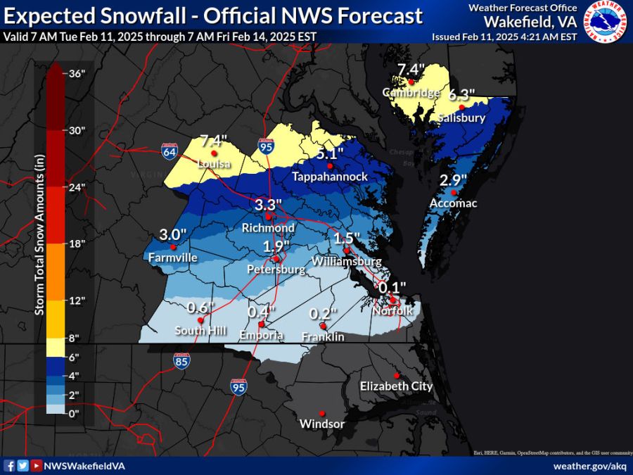
So here’s my latest snowfall forecast.
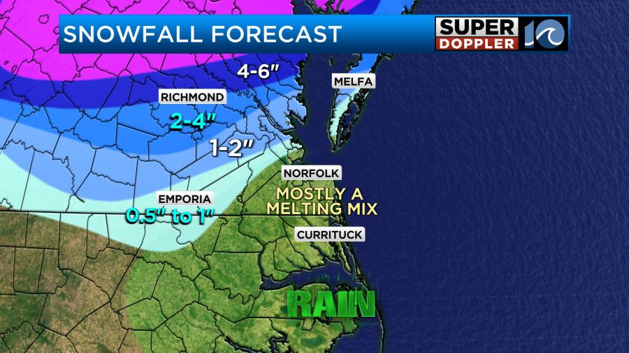
There may be some spots where it starts to stick to some grassy areas in the “melting mix” zone, but it shouldn’t last too long if it does. I Do have the higher amounts to the north and northwest as the other models do. It will be difficult to actually tell how much snow will be on the ground in the end as that melt zone moves northward today.
After all of this wintry weather then we will have lots of rainfall. We do need it, but it may be a little too-much too-soon. Here is the rainfall forecast for the next 48 hours.
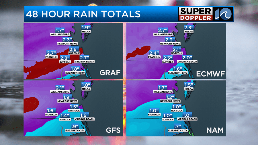
At least this will really knock down the current drought. Stay tuned for updates.
Meteorologist: Jeremy Wheeler


